This is our biggest and most exciting update so far, and we think that you will be very happy with the changes made to our core features and the new features we've added.
Our goal with Zonegoat has always been to help commercial real estate agents find properties that are zoned for Cannabis. Our main feature was allowing agents to explore municipality regulations and to explore boundaries in those municipalities. Unfortunately, before this redesign we didn’t have the ability to display properties, Zonegoat was allowing real estate agents to identify zones with no boundaries but wasn’t helping agents find properties in those zones. We realized that there was an issue with our UX and that we needed to revamp our core features, and for these past three months we did just that.
What's New on Zonegoat Feature by Feature
BROWSE FEATURE
We've completely redesigned the Overview section to provide the most essential information to our users. Browse now has a completely new overview section with less information clutter. When you navigate to a municipality you will be able to view the limits right away.

We've also added an accordion display for any additional information such as Zoning Distance Rules, Zoning Districts and Municipality Maps & Bylaws. So don't worry, all the additional information you were utilizing before are still accessible from the click of a mouse.

We've improved how users find and explore municipalities with a brand new Search Layout and Search Filters.

When a municipality of interest had a limit or didn't allow marijuana, there was no intuitive way to explore municipalities nearby. So, we've added Municipalities Nearby.

Our analytics showed that less than 1% of our users were using Zoning Simulation so we decided to remove direct access to the feature. This will allow us to focus all our efforts on maintaining and improving our core features and to provide simulation on-demand to whoever needs it. For our users who still need Simulation, the feature will now be available on demand.

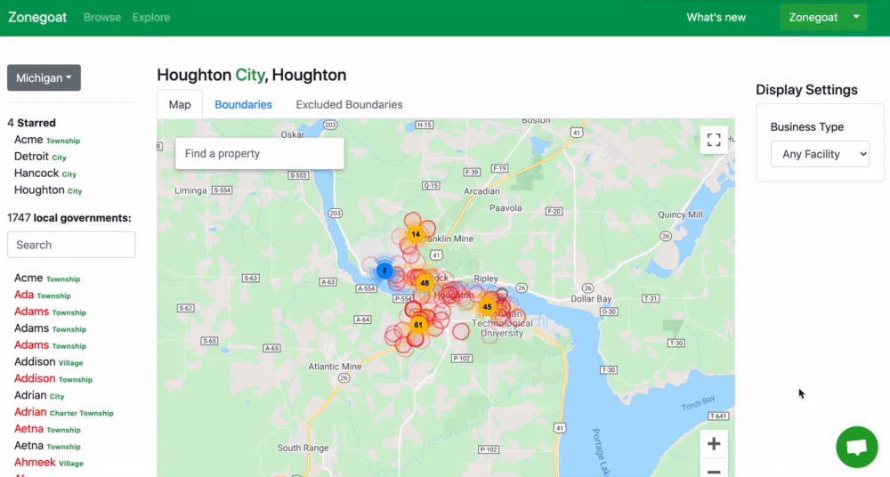
MAP FEATURE
We've completely redesigned the Map Feature to make it more interactive and we've added the anticipated Property Feature. You can now explore and discover opportunities directly from the Map. Our new property feature will tell you right away the current estimate we have for a property: If it has No Boundaries and if it is Zoned. To run a more detailed report you can Run a Zoning Report.

You can now easily view all parcels near a property including the property itself. The Parcel Number for each property is now available on the Zoning Report that you can run anytime at no extra cost.

If you'd like more information about a property; the broker information is available on the Property Card. You can also easily save your property of interest and run a zoning report for those properties later.

When a listing is fetched from Public record, we make it easy for you to directly access the original listings:

ZONING REPORT FEATURE
Our detailed Zoning Report was improved with Parcel Details, Parcel Numbers and Owner's Name.

Review the parcel of a property that is estimated to be zoned including the boundaries detected nearby. And know exactly why a property is estimated to be within boundary limits.

DASHBOARD
We've added a brand new dashboard that gives you a quick overview of your property saved and quick links to help you with your search.

DETAILED ZONING COVERAGE
It took us a while to figure out the best way to provide you with a clear overview of our data coverage. If you'd like to know where we are in terms of data collection this is a quick and easy way to find out. We believe that being transparent as possible with our progress and it allows you to have a bigger understanding of how Zonegoat can help you with your search.

We are collecting data every day and we're always looking for new ways to collect data faster. We've recently made some internal changes that will allow us to collect our next batch of data at 15x the rate at which we were collecting it so far. This update will allow us to collect more municipalities and additional states faster. Because of this major change that is taking place on our data strategy, we believe that once this is fully implemented, we will be able to collect data nationwide faster than anticipated, and we might be able to reach that target before the end of the year. You can consult our coverage at any time or stay tuned with our announcements.
CREDITS SYSTEM & USAGE QUOTA
Bringing you all the features that Zonegoat provides doesn't come without cost. But we're always negotiating with our partners to find better ways to provide you with the services that Zonegoat provides at an affordable cost. We couldn't provide unlimited usage, but we wanted to give our users the ability to only pay for what they use. The beauty of a credit system is that it allows us to anticipate total usage while being able to afford and provide our service and allow our users to only pay for the credit they need and use them as they go.
The next time you open the map, you'll notice a new section that might look unfamiliar.

This is your Credit Usage Quota. Your total credit will be based on your plan. You might wonder how we price actions with credits. We like to keep things simple so we kept the cost of each action simple and easy to remember:
- Browsing Municipalities ( Unlimited with a subscription – No Credit required )
- Search ( 10 credits )
- Show property parcel ( 1 credit )
- Zoning Reports ( 40 credits )
That means that as long as you have an active subscription, browsing municipalities won't cost you a single credit (Yes, that's right! ). You only pay credits when you use the map to find opportunities, view a property parcel and/or run a zoning report.
By giving you unlimited access to the Browse feature, we hope that it will give you all the time you need to narrow down your areas of focus before exploring opportunities.
FREE TRIAL
We always wanted to make it easier for everyone to have the ability to experience the value of Zonegoat before having to pay for it. Since we changed our business model to a credit system, it's now much easier for us to offer a Free Trial.
When you sign up for Zonegoat you automatically get a 7 days Free Trial with 100 credits. It gives you enough credits to experience our product and see if Zonegoat is for you. When you're ready to upgrade and put your team on it, you can contact sales and our team and customer success manager will be happy to assist you.
MULTIPLE USERS SUPPORT
By opening our Sign Up process to everyone, we've also made it easier for new users to create an organization or join their existing organization when their team is already on Zonegoat.

To add a user right now the organization admin will need to contact us via the chat but don't worry, your organization admin will soon have the ability to invite users right from his dashboard.
WHAT'S NEXT 😆
As you can see, these past three months moved at a very fast pace, but we don't intend to slow down. There are still a lot of things we are planning to achieve in the next couple of weeks. Here's what to expect:
- We're Adding A LOT MORE municipalities data, including new states! We're adding new data daily, but since we are revamping our data collection strategy, when it is fully implemented you can expect to see a much larger set of data added into our system within the next few weeks. More municipality data also means that you'll be able to run zoning reports in more municipalities.
- We're Adding Zoning District Validation which will allow us to display Zoning District Name and Code for any address. This is a much-anticipated feature that will greatly improve our Zoning Algorithm. We've been working on it for months, and we're excited to announce that we are a few weeks away from launching.
Do let us know how excited you are about these new updates! And please don't hesitate to reach out via email to share your experience with us. We can't wait to hear from you!